Digital Twin für Sarajevo

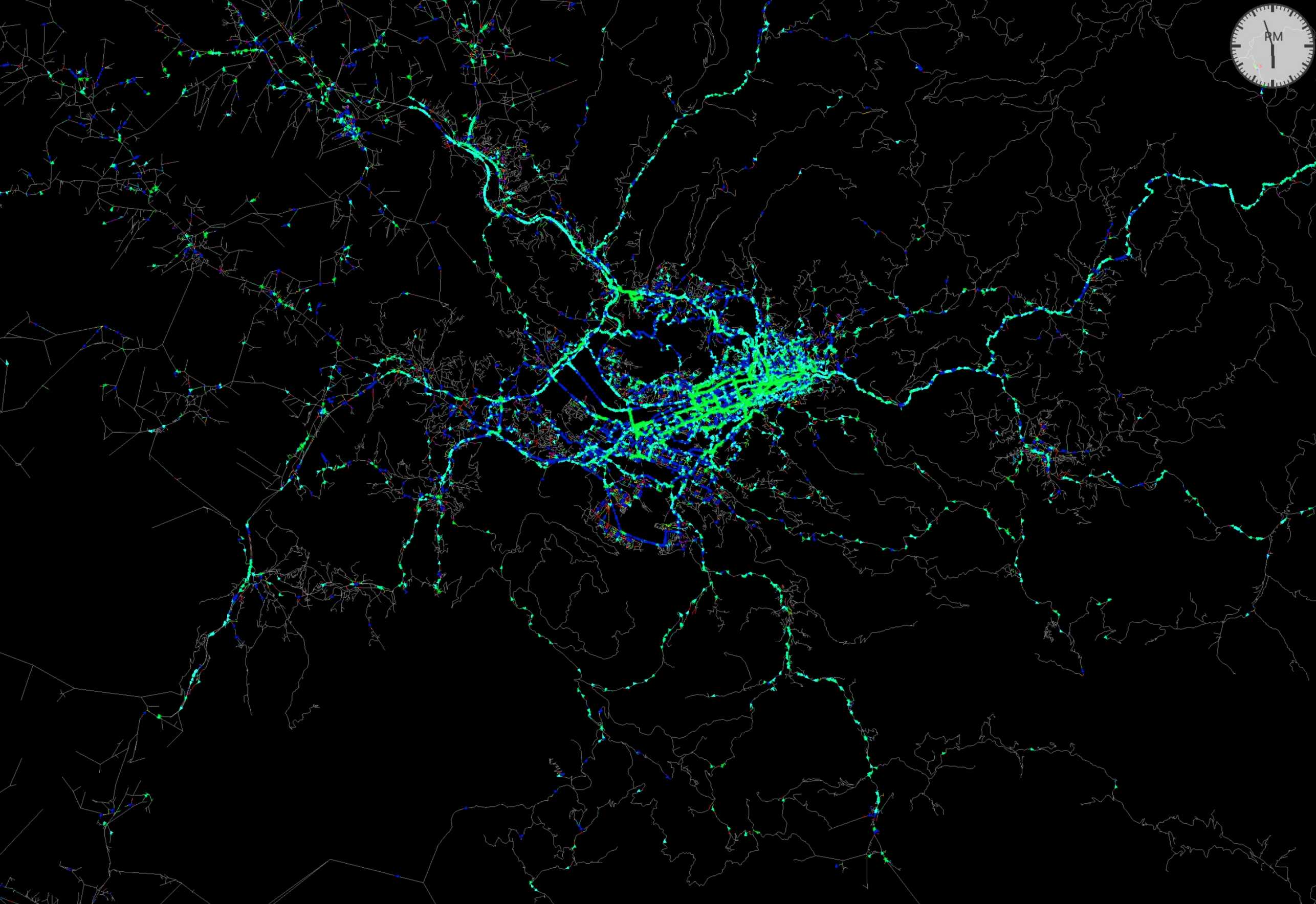
Professor Hubert Klumpner’s chair designed the first AI-supported 4D model for Sarajevo. It takes spatial and temporal dimension into account in urban planning and was the basis for public hearings. “To map the complexity of the city, we need new methods, processes and technologies,” says Klumpner.

“Architecture can’t wait,” says Hubert Klumpner. The ETH professor and his team at the Chair of Architecture and Urban Design research, plan and build in places that, after crises and conflicts, use the opportunity to reinvent themselves as a city and society. In the Colombian city of Medellín, which was once one of the most dangerous places in South America. In Kigali, Rwanda, where a civil war was taking place. Or in Sarajevo, the capital of Bosnia and Herzegovina, which resisted the siege for 1,425 days. “We work on real-world problems and recognize the opportunities in places that lie outside the usual debate about western cities,” says Klumpner.

The last version of the master plan for Sarajevo dates back to 1984, when the Winter Olympics were held in the city. The “Urban Transformation Project Sarajevo” designs a perspective for the development of the city up to 2040. Involved are together with Klumpner’s professorship, the Laboratory of Energy Conversion of Professor Abhari at D-MAVT, the ETH spin-off SwissAI, the University of Sarajevo, the Planning Office of the Canton of Sarajevo and the City of Zurich. The project is part of a long-term collaboration with the State Secretariat for Economic Affairs SECO, which supports Klumpner’s research work in South America, Africa and, since 2018, in the Balkans.

In order to better understand Sarajevo, Hubert Klumpner’s professorship, led by post-doc Michael Walczak’s research group, has designed the first computer-aided 4D model for the city and canton of Sarajevo. It combines quantitative and qualitative data to make complex planning decisions. Researchers in Sarajevo collected the data for this city’s first Digital Twin using a mobile laboratory called “Studio Mobil”.

The result is a “digital urban imaginarium” of the built and natural environment. It contains information on infrastructure, mobility, energy, water, air and soil quality, but also on people’s behavior and demographics. “In order to be able to map the complexity of the city, we need new methods, processes and technologies,” says Klumpner.

Das Studio Mobil war in allen neuen Stadtgemeinden von Sarajevo
The “Studio Mobil” was present in all nine municipalities of Sarajevo. (Photo: Prof. Hubert Klumpner, Chair of Architecture and Urban Design)
The Digital Twin connects different scales and takes topography, climate, every building and every vehicle into account. The model depicts energy consumption at any time of the day and night in order to be able to represent the behavior of people in the city. They are depicted as “agents” in the model with the help of machine learning algorithms. In this way, the simulation can understand how individual people move, where they live, and how they work.

The digital twin includes the built and natural environment, but also social scientific data such as the diverse cultural, ethnic and religious characteristics of different neighborhoods. In addition to the spatial dimension, the multidimensional plan takes into account the temporal dimension in urban planning. For example, every single second of traffic behavior can be tracked and visualized in real time.

Das digitale Modell simuliert jede Sekunde des Verkehrsverhaltens
The digital model simulates every second of traffic behavior. (Photo: Dr. Michael Walczak, Chair of Architecture and Urban Design)
The researchers do not blindly trust the digital data; the simulations were checked and calibrated on site. The “Studio Mobil” was present at strategic locations in the nine city districts for public hearings. At the same time, a cartography of wind movements was created and traffic behavior was recorded. In this way, research combines quantitative and qualitative data and empowers the population in the process. “We are not planning a smart city, we are working with smart people on the future of their city,” says Klumpner.

Until now, the city was thought of as a linear structure along a one-way street in a river valley. The new master plan describes the urban development around the city hill as a green heart. It focuses on the cross-relationships in the valley and also takes into account the hillside settlements, where 40 percent of the population lives. Sarajevo is currently one of the ten cities in the world with the worst air quality. The plan calls for non-fossil energy sources for transport and heating. In addition, the forest areas should be protected and regenerated in order to improve the air quality in the city.

Der neue Masterplan beschreibt die Stadtentwicklung rund um den Stadtberg als grünes Herz
The new master plan describes the urban development around the city hill as a green heart. (Plan: Dr. Michael Walczak, Chair of Architecture and Urban Design)
The cantonal planning office is already using the Digital Twin to implement alternative urban planning. The digital model is not a fixed plan, but a planning tool for decision-making. It links various parameters and thus reflects the complexity of an urban structure. And with the twin, planners can simulate scenarios and see how, for example, a new road will affect traffic flow or air quality.

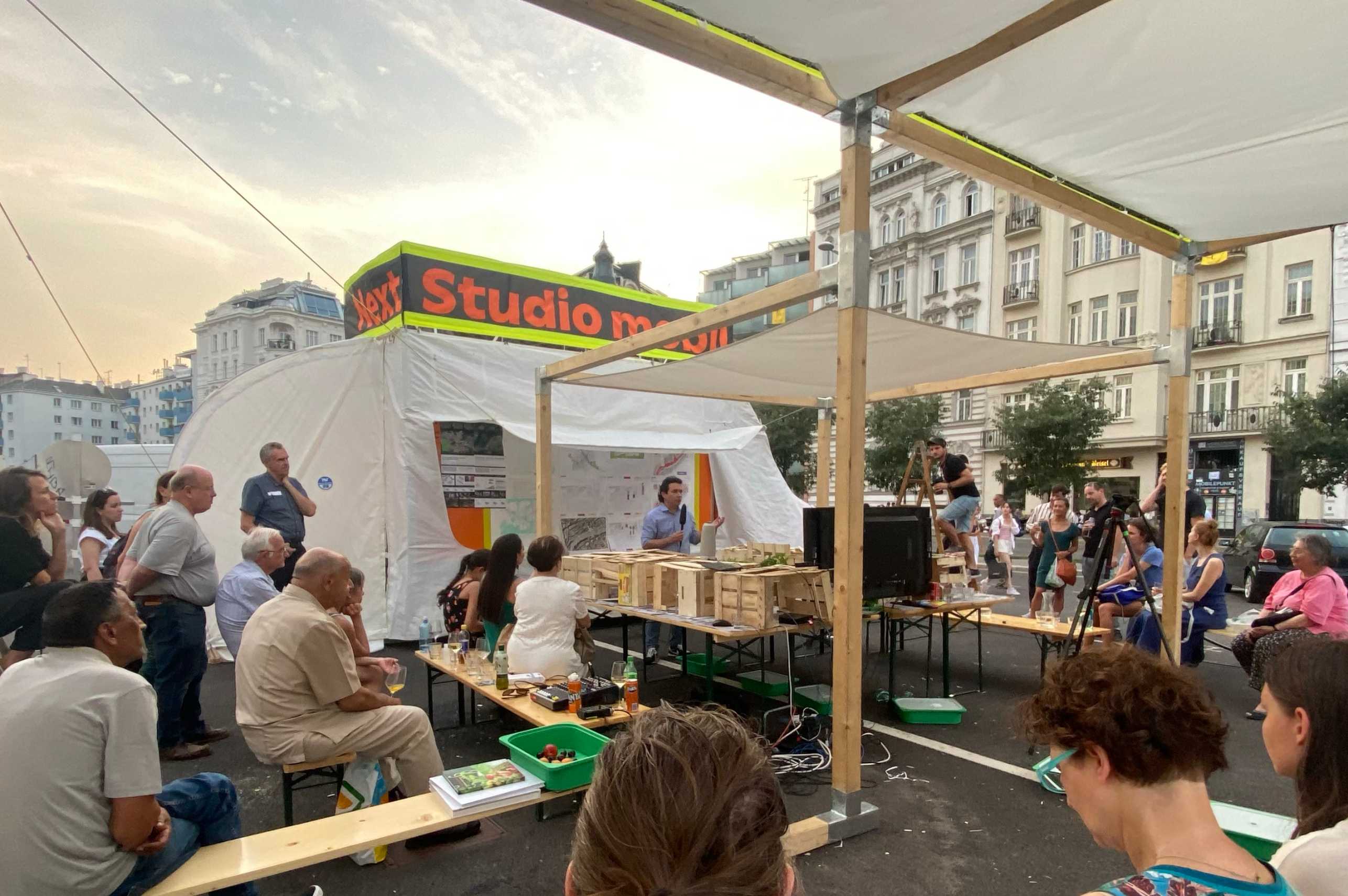
The Digital Twin was the basis for public hearings, which are required by law for planning in Bosnia and Herzegovina and which took place until the end of April. The researchers speak of “bottom-up simulations”. To make the Digital Twin more accessible, they built a physical model of the city overlaid with projections. A web-based model allowed people to participate remotely. Some key locations in the city were animated on a 1:1 scale in order to convey them clearly.

Die Beteiligten stehen vor dem physischen Modell der Stadt während dem Entwurfsstudio in Sarajevo 2023.

The events took place in all nine municipalities of Sarajevo, and their input is now being incorporated into the model. An accompanying exhibition is currently touring the six Western Balkan states and will be on display at the Museum of Applied Arts in Belgrade from February 2025.

In 1984 the Winter Olympics took place in Sarajevo. The war raged from 1992 to 1995. Today, almost 30 years later, the city has changed. At the end of April, 18 mayors from Ukraine visited Sarajevo to find out how a city can reinvent itself after a state of war – supported with new digital planning tools.

Hack Archthon in Sarajevo während dem "Urban Design Studio Sarajevo"
Hack Archthon in Sarajevo during the “Urban Design Studio Sarajevo” (Photo: Dr. Michael Walczak, Chair of Architecture and Urban Design)
The Learning & Teaching Fair 2024 brings together 42 innovative teaching projects at ETH. This also includes the “Hack Archthon”, which Hubert Klumper’s chair organized in Sarajevo in the spring semester of 2024. Students spent a week programming tools to visualize the data of the Digital Twin. In the end, the best performers were awarded an Olympic medal. ETH supported the teaching concept with an Innovedum grant.

Related posts

This site is registered on wpml.org as a development site. Switch to a production site key to remove this banner.